


Basic boating rules checklist
Before heading out on the water, take a few minutes to run through these basic rules for safe boating – they could make all the difference:
- Know the area in which you are boating and seek local knowledge.
- Check the weather before and during your trip including tide and the expected sea conditions.
- Tell someone where you are going and when you will return.
- Know the limitations of your boat.
- Know your own limitations – if you’re in any doubt, come in.
- Carry the right safety gear and know how to use it.
- Don’t commit yourself to the trip – cancel if the weather is bad.
- Know the load limit of your boat and don’t exceed it.
- Carry some spare fuel and basic spare parts.
- Wear a life jacket at all times on boats 6m and under.
- Keep an eye on children and put them in a life jacket at the boat ramp.
- Alcohol and boating don’t mix.
Test your knowledge – take the MAST 30 second challenge
New to boating? ‘What you must always do’ tips
- Take it easy – even the most experienced boaters can get into trouble.
- Knowledge and skills come from experience – this takes time.
- Perhaps start in calm conditions and work your way up.
- Don’t be overconfident – a licence means you know the rules, but you still have no experience.
- Now that you hold a boat licence, you have the responsibility of your passengers.
Boat and gear safety checklist
Sometimes we take the condition of our boat and our gear for granted. Mast’s comprehensive boat and gear safety checklist covers most areas of all boats of various shapes and sizes.
Please download a copy of MAST’s checklist and spend some time reviewing each point to ensure your boat and gear are in good working order and up to date. MAST recommends copying and enlarging the outline of your boat, and noting the location of your safety and other gear, then laminating it and mounting it on the bulkhead. This will help all onboard locate gear to prepare for a trip or in an emergency.
Planning your trip checklist
Now that you know that your boat and gear are in good condition, it’s time to plan a trip. Before you head out on the water, ask yourself these questions.
- Do you hold a current licence?
- Has the latest weather forecast been checked?
- Has the tide been checked to ensure the ramp is suitable?
- Has the vessel and safety equipment been checked?
- Is there enough fuel for the trip (and reserve)?
- Is there sufficient food, water and a first aid kit?
- Have you informed someone of your departure and estimated return?
- Are you familiar with the area you intend going, or have you sought local knowledge?
- Are all passengers familiar with the safety equipment?
Weather
Remember, Tasmania’s weather is variable and can change rapidly.
Good weather is critical for a safe and enjoyable trip; therefore, it is important to always obtain an up-to-date weather forecast before going boating.
‘What you need to check’ weather tips
A weather forecast will include information on wind direction and speed, as well as the state of the sea and swell. If the weather is not suitable, cancel your trip.
Routine forecasts and observation reports for coastal waters areas within 60 nautical miles of the coast and larger inland lakes are issued twice daily.
Warnings are also issued whenever strong winds, gales, storm-force or greater winds are expected, and are renewed every six hours.
Wind alerts are issued for Southeast Coast, Southwest coast and Central Plateau lakes as required.
There are many ways of obtaining an up-to-date forecast for any of the Tasmanian coastal waters and the larger Central Plateau and Southwest Lakes.
Links to weather information resources
Below is a list of websites, apps, and phone numbers you can use or contact for up-to-date weather information.
Routine boating forecasts are issued for nine Tasmanian coastal regions as well as inland waters such as larger Central Plateau and Southwest lakes.
The Bureau of Meteorology issues forecasts for all these regions twice daily at 5.00am and 4.00pm.
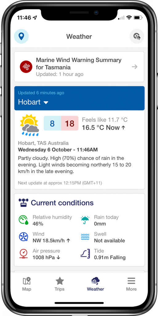
DECKEE gives boaters access to location based information that changes depending on where you are and what activity you are undertaking. Key features include:
• Explore Tasmanian waterways virtually – through the app, you can see photos of locations, anchorage locations, and you can also share your experience.
• Personalised marine weather forecasts – combining Bureau of Meteorology (BOM) data with your vessel type to help you decide the best time to head out.
• Journey sharing – provide your safety contacts with all your trip details.
DECKEE is available on the App Store and Google Play Store for both iOS and Android devices, so download it now and add it to your boating safety kit.
MAST Telephone weather service
Forecasts on this system are updated twice daily. The service is the cost of a local call, and you can get a forecast for your area by dialling one of the numbers listed below.
Southern Tasmania (03) 6233 9955
Northern Tasmania (03) 6323 2555
Eastern Tasmania (03) 6376 0555
North-West Tasmania (03) 6498 7755
The Bureau of Meteorology Phone Service
Boating weather forecasts, warnings and observations
Phone: 1900 969 940 (Cost 77 cents/min)
All current warnings
Phone: 1300 659 216 (cost of a local call).
Save all these numbers in your mobile phone.
The Bureau of Meteorology website provides access to weather forecasts and weather observations.
Bureau of Meteorology Marine Wind Warning Summary
Meteye is an online mapping tool or Geographic Information System (GIS) used to visualise weather data for Australia.
The ‘Meteye‘ system allows you to easily search for your local weather data, save your favourite locations and combine the latest weather and forecast weather on one map (rain radar, cloud, temperature, rainfall, wind, waves).
The Bureau of Meteorology also has a new mobile weather website for smartphone users which is a condensed and reformatted version of the full Bureau website, customised for small screens.
The mobile site URL is m.bom.gov.au.
Current weather forecasts are available via VHF radio. Volunteer coastal radio stations broadcast forecasts at particular times and can provide a forecast upon request at any other time.
Warnings and forecasts are broadcast by these groups on both VHF Channel 16 and 67.
Many radio stations broadcast comprehensive weather forecasts.
Wind direction is given in 8 compass points for forecasts and 16 for observations and is the direction the wind is coming from.
Wave height is the vertical distance between the top of the crest and the bottom of the trough.
Wind speed refers to the average speed over a 10 minute period at a height of 10 metres above the surface and is given in knots. A knot (kn) is equal to a speed of one nautical mile per hour. Note: 10 knots = 18.5 km/h and 10km/h = 5.4 knots.
Gusts may be up to 40 per cent stronger than the average speed.
A squall is an abrupt and large increase of wind speed with a duration in the order of minutes which diminishes rather suddenly.
Wave and swell heights are described in terms of significant wave height, which represents the average of the highest one-third of waves. Some waves will be higher and some lower than the significant wave height. Typically one in 2000 waves will be twice this height.
King/freak/rogue waves occur when wind waves and/or a combination of swell waves join to produce a very high wave. These waves can be much larger than the significant wave height.
Wind and warning categories
Coastal waters wind warnings issued by the Bureau are categorised as follows:
Strong wind warning: Winds averaging from 26 knots and up to 33 knots
Gale warning: Winds averaging from 34 knots and up to 47 knots
Storm force wind warning: Winds averaging from 48 knots and up to 63 knots
Hurricane force wind warning: Winds averaging 64 knots or more
Inland waters wind alerts are issued for winds averaging 20 knots or more.
Conversion: 1 knot = 1 nautical mile per hour = 1.85 kilometres per hour.
Note: Wind speed is a ten-minute average, and gusts may be up to 40% stronger
Strong wind warnings for coastal waters only/