Marine and Safety Tasmania (MAST), on behalf of the State Government and with the assistance of the Dorset Council, is assessing options and undertaking stakeholder engagement to identify the preferred location for a new Pier in Bridport.
The Government’s election commitment is to provide Bridport with a recreational Pier that can be used by the local community and visitors to the area.
Proposed New Bridport Pier – Site Appraisal
Marine and Safety Tasmania (MAST), on behalf of the State Government and with the assistance of the Dorset Council, is undertaking stakeholder engagement and site assessments to identify the community’s preferred location for a new recreational pier in Bridport.
Site 1 – Old Pier
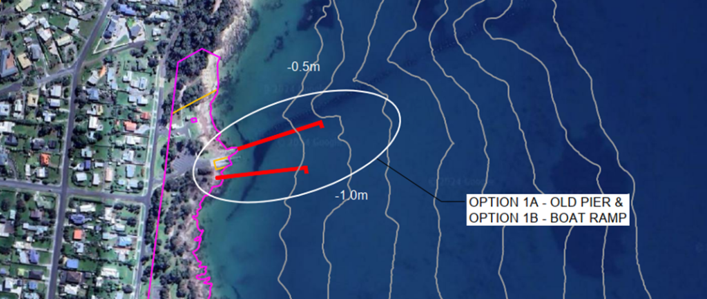
- Pier Length = 126m
- Seabed depth at jetty end (Option 1A – Adjacent to Old Pier) = -0.8m CD
- Seabed depth as jetty end (Option 1B – South of boat ramp) = -0.6m CD
Advantages:
- Existing car parking infrastructure (has potential for expanding car parking facilities).
- Existing and accessible amenities (toilet facilities, picnic tables etc.).
- Proximity to local swimming beaches.
- Safe marine environment for accessing the ocean.
- Consolidation with existing marine infrastructure (boat ramp).
- Generally protected from prevailing winter weather.
- Cost-effective access for lighting, electrical and water use for on the Pier.
- Historical links with Old Pier location.
- Adequate depth of water for Pier.
Limitations:
- Increased traffic volumes and associated impacts along Bentley Street.
- Logistically separated from the town centre (approx. 1.3 km southward) potentially reducing benefits of the Pier.
- Potential aesthetic impact to vantage points of the iconic Old Pier piles (Option 1A).
- Increased use pressure on existing car parking areas and amenities facilities.
- Impact on the coastal area and beach amenities.
- Restrict the visual amenity of nearby residents.
Site 2 – Croquet Lawn Beach
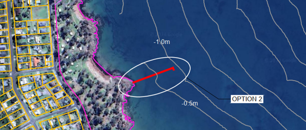
- Pier Length = 126m
- Seabed depth at jetty end = -0.9m CD
Advantages:
- Central location for caravan park users.
- Adequate land for potential increase in development.
- Improved proximity to business activity area (approx. 600 metres).
- Proximity to local swimming beaches.
- Safe marine environment for accessing the ocean.
- Adequate depth of water for Pier.
Limitations:
- Increased traffic volumes and associated impacts along Bentley Street.
- The existing informal car parking area would require upgrading to meet current standards.
- Intensified traffic volumes and associated amenity/safety impacts upon caravan park users
- Increased use would accelerate the deterioration of internal road networks to access the Pier.
- Increased use would put pressure on public amenities.
- Reduce the amenity and area of the caravan park for users.
- Impact on the coastal area and beach amenities.
- Restrict the visual amenity of nearby residents.
Site 3 – Goftons Beach
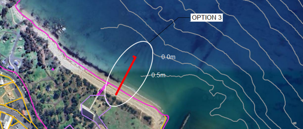
- Pier Length = 126m
- Seabed depth at jetty end = +0.3m CD
Advantages:
- Proximity to town centre and business area (approx. 300 metres).
- Centrally positioned along the foreshore for connection with visitors.
- Good pedestrian accessibility for the public.
- Good visual point and lookout for visitors from town and vessel movement into port.
- Consolidates with existing recreational facilities adjacent (playground, Surf Lifesaving Club and public open space)
- Sufficient existing vehicle parking areas and nearby amenities.
Limitations:
- Restricted water depths for the majority length of a Pier (exposed sand at lowest tides).
- Impact on the coastal area and beach amenities.
- Hinder the activities and use of the Bridport Surf Lifesaving Club.
- Community events are based near this location, any land-based upgrades to car parking area could reduce ability to use the area.
- Sedimentation and sand migration – the channel entrance has traditionally faced the problem of the buildup of coastal sediments which occurs as a result of longshore sediment transport.
Relevant Information for all sites
- Department of Natural Resources and Environment (NRE Tas)-Property Services’ approval required.
- Planning Scheme approval required.
- The project will require a land and marine-based environmental assessment to ensure compliance with relevant legislation.
- A coastal erosion and inundation report will likely be required to demonstrate that it can maintain a tolerable risk from coastal inundation.
- A geotechnical assessment will need to be completed for the preferred site to aid the detail design.
- Design is based on election commitment of 126 lineal metre pier length and allocated budget.
- Tide within Bridport area is relative to Low Head. Pier water depths noted are relative to Chart Datum (CD):
- Highest Astronomical Tide (HAT) = 3.6m CD
- Mean Higher High Water (MHHW) = 3.3m CD
- Mean Sea Level (MSL) = 2.1m CD
- Mean Lower Low Water (MLLW) = 0.7m CD
- Lowest Astronomical Tide (LAT) = 0.0m CD