• News
  • Facilities Finder
  • Fees and Forms
  • Notices to Mariners
  • MAST GIS
  • Contact us
  • Payments
Translation Logo Disclaimer
Marine and Safety Tasmania
  • Licensing
  • Registration
  • Moorings
  • Safe Boating
  • Safe Navigation
  • Licensing
    • How to obtain a Motor Boat Licence
    • Accredited Providers
    • Licence Check
    • Practice test
    • PWC Endorsement
  • Registration
    • How to Register a Boat or PWC
    • Buying or Selling a Motor Boat
    • Boat and PWC Registration Check
  • Moorings
    • Applying for a New Mooring
    • Buying an Existing Mooring
    • Change of Vessel Details
    • Increasing vessel length
    • MAST Web Based Mooring and Facilities GIS Mapping System
    • Mooring Audits
    • Mooring Contractors
    • Mooring Maintenance
    • Repair and Maintenance of Vessels on Moorings
    • Mooring Permit checker
    • MAST Public Cruising Moorings
  • Safe Boating
    • Carbon Monoxide (CO)
    • Incidents
    • Marine Safety Guides & Tips
    • Paddle Craft
    • Personal Water Craft (PWC)
    • Publications
    • Rowing
    • Safe Boating Handbook
    • Safety Equipment
    • Trip Preparation
    • Vessel Handling and Operations
    • Vessel Maintenance, Buoyancy and Capacity
    • Marine Communications
    • Water Sports
  • Safe Navigation
    • Aquatic Events / Designated Ski Areas
    • Boating Guides
    • Cruising Tasmania
    • Denison Canal
    • Lake Barrington
    • Marine Farming
    • Navigation Rules
    • Operational Areas
    • Operating in Port Areas
    • Prohibited Zones
    • Speed limits
    • Tasman Bridge, Bowen Bridge and Bridgewater Bridge
    • Whales
Marine and Safety Tasmania
  • Licensing
    • How to obtain a Motor Boat Licence
    • Accredited Providers
    • Licence Check
    • Practice test
    • PWC Endorsement
  • Registration
    • How to Register a Boat or PWC
    • Buying or Selling a Motor Boat
    • Boat and PWC Registration Check
  • Moorings
    • Applying for a New Mooring
    • Buying an Existing Mooring
    • Change of Vessel Details
    • Increasing vessel length
    • MAST Web Based Mooring and Facilities GIS Mapping System
    • Mooring Audits
    • Mooring Contractors
    • Mooring Maintenance
    • Repair and Maintenance of Vessels on Moorings
    • Mooring Permit checker
    • MAST Public Cruising Moorings
  • Safe Boating
    • Carbon Monoxide (CO)
    • Incidents
    • Marine Safety Guides & Tips
    • Paddle Craft
    • Personal Water Craft (PWC)
    • Publications
    • Rowing
    • Safe Boating Handbook
    • Safety Equipment
    • Trip Preparation
    • Vessel Handling and Operations
    • Vessel Maintenance, Buoyancy and Capacity
    • Marine Communications
    • Water Sports
  • Safe Navigation
    • Aquatic Events / Designated Ski Areas
    • Boating Guides
    • Cruising Tasmania
    • Denison Canal
    • Lake Barrington
    • Marine Farming
    • Navigation Rules
    • Operational Areas
    • Operating in Port Areas
    • Prohibited Zones
    • Speed limits
    • Tasman Bridge, Bowen Bridge and Bridgewater Bridge
    • Whales
  • News
  • Facilities Finder
  • Fees and Forms
  • Notices to Mariners
  • MAST GIS
  • Contact us
  • Payments
Disclaimer

Safe navigation

Boating Guides

These guides provide important information such as transit times, safe anchorages and the location of facilities.

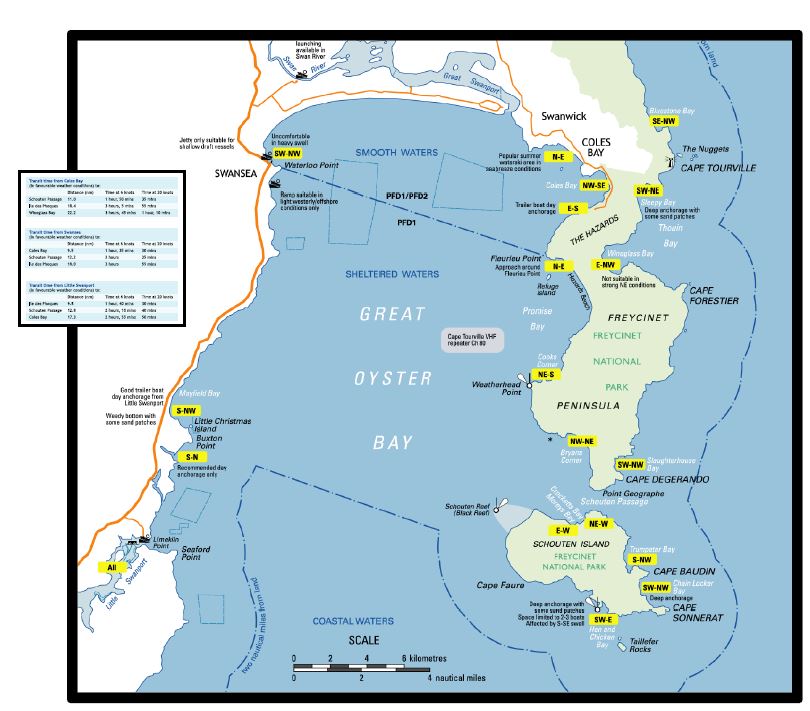
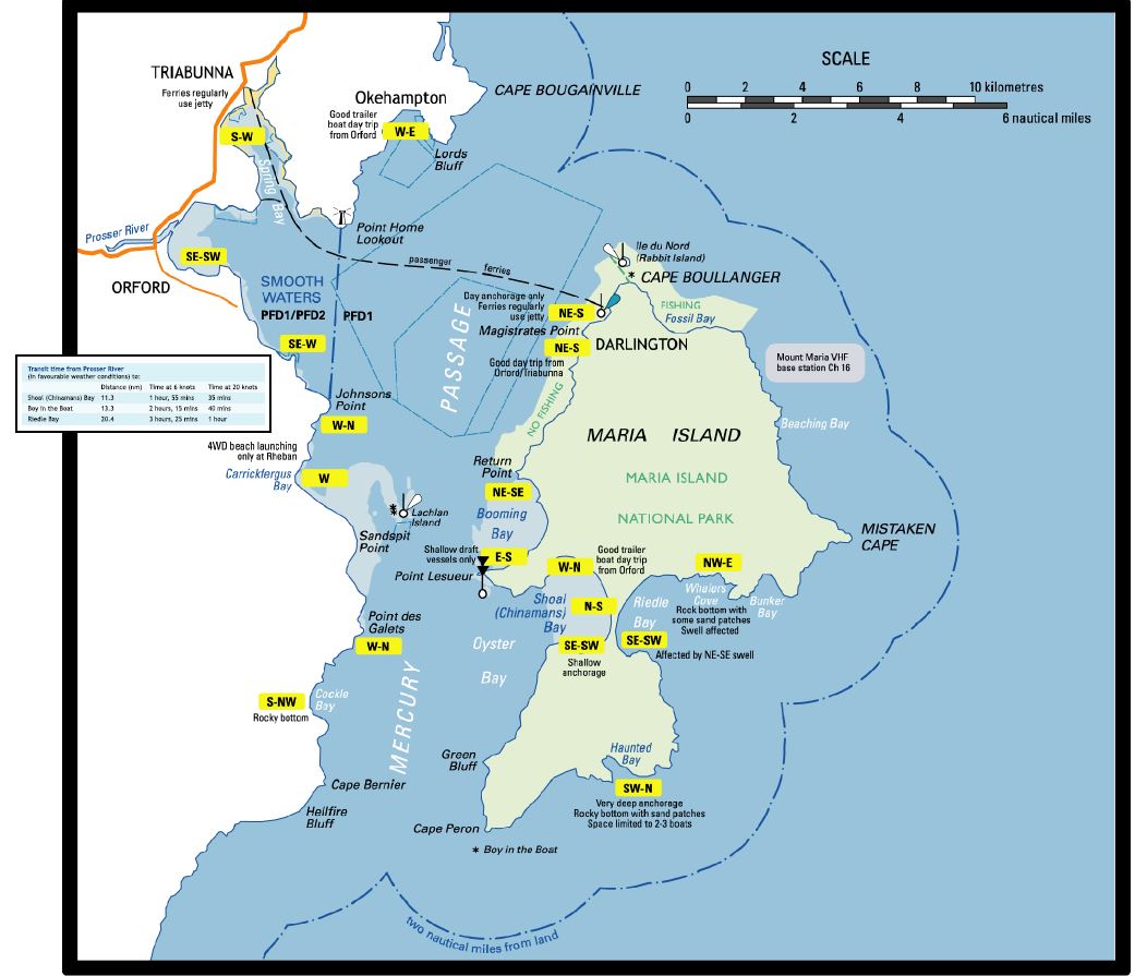
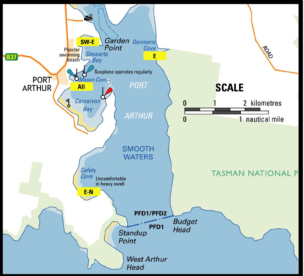
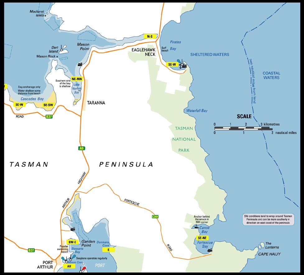
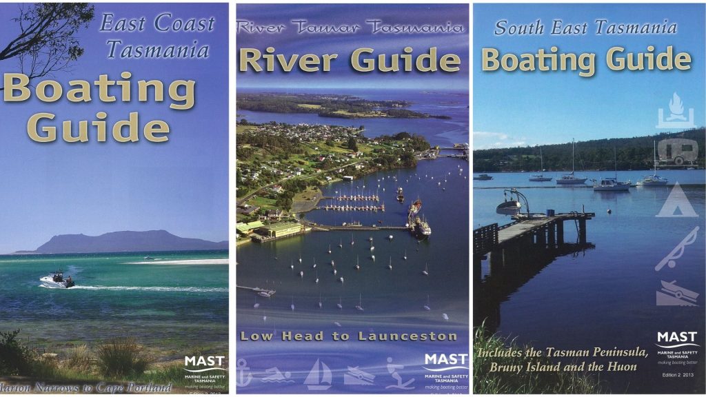
The Tamar River Guide, South East Boating Guide and East Coast Boating Guide are available from MAST at a cost of $3.30.

  • Address:  Level 1, Port Tower Building, 18 Hunter Street, Hobart.
  • Email:  admin@mast.tas.gov.au
Boating Guides
River Tamar Boating Guide 5mbDownload
South East Tasmania Boating GuideDownload
  • South East Tasmania Boating Guide (PDF)

Signage Maps

Adventure-BayDownload
Norfolk-BayDownload
Dolphin SandsDownload
Channel-LowerDownload
Channel-UpperDownload
Frederick-Henry-BayDownload
Frederick Henry Bay 1Download
Great-Oyster-BayDownload
Mercury-PassageDownload
Port-ArthurDownload
Tasman-PeninsulaDownload
Georges BayDownload
Blackman-BayDownload

Safe Navigation

  • Aquatic Events / Designated Ski Areas
  • Boating Guides
  • Cruising Tasmania
    • West Coast Tasmania
    • Macquarie Harbour
    • Bruny – D’Entrecasteaux Channel and Huon River
    • Tasman Peninsula
    • East Coast Tasmania
    • Northern Tasmania – Flinders Island and Deal Island
    • North West Tasmania
  • Denison Canal
  • Lake Barrington
  • Marine Farming
  • Navigation Rules
    • Navigation Marks
    • Navigation Lights
  • Operating in Port Areas
  • Operational Areas
  • Prohibited Zones
  • Speed limits
  • Tasman Bridge, Bowen Bridge and Bridgewater Bridge
  • Whales

Related Information

Safe navigation

Cruising Tasmania

The secret behind every successful cruise is careful planning. Preparing for an extended cruise usually takes months with researching anchorages, organising the boat, looking at refuelling options and availability of crew.

Marine Safety Guides & Tips

Tassie’s BoatWISE Buddy

A ready reference guide book for Tasmanian boaters.

Safe navigation

Navigation Rules

Navigation rules are often called ‘rules of the road at sea’ and apply to all boats. These rules give clear indication about passing, approaching, giving way and overtaking other boats.

Be Boatwise

Marine Safety Guides & Tips

Take the 30 Second Challenge

Read more

Publications

Read the Boatwise magazine

Summer 2022 edition of Boatwise

Read more

Our newsletter keeps you up to date

Sign up

Follow us on

  • Facebook
  • Youtube
  • About
  • Policies and Legislation
  • Commercial
  • Contact
  • Educational Resources for Schools
  • Calendar of Upcoming Aquatic Events
  • Boat Ramp Etiquette

© 2020 Marine & Safety Tasmania | Copyright & Disclaimer

Web Design by Ionata Digital