Travelling at speed may be dangerous in these situations and all skippers must be alert and responsible around other boats and people in the water and ensure that they observe the legislated speed requirements under the MAST By-Laws, as penalties do apply.
For these reasons, there are defined speed limits for operating in close proximity to other vessels and the shore. Additionally, certain areas are also designated as 5-knot zones. These defined areas are typically located around popular swimming beaches, where MAST has previously encountered dangerous behaviour from PWC and boat operators in close proximity to swimmers.
The following speed limits apply to vessels operating within close proximity to other vessels, or the shore, and swimmers/divers and on the spot fines can be issued to offenders:
- No vessel shall exceed a speed of 5 knots when within 60 metres of a wharf, jetty, mooring, the shoreline or another boat
- No vessel shall exceed a speed of 5 knots when within 120 metres of a person swimming, a person diving (displaying the A flag) or a person wading in the water. There are also a number of designated areas around the State where a speed limit of 5 knots exists.
Excessive speed on the water is a serious safety matter. 5 knots is commonly referred to as a fast walking speed. A boat that is planing is exceeding a speed of 5 knots.
Freestyling
Freestyling means erratic and non-directional driving which can make it difficult for others to predict the motor boat’s course to avoid a collision. It includes wake jumping and tight turns such as donuts.
Motor boats, including PWC, are not permitted to operate in a “freestyle” manner when within 200 metres of a swimmer, or 200 metres of the shore if a dwelling is within 100 metres of that shoreline.
5 knot zones
Certain areas are defined as 5 knot zones. This means that vessels operating within these areas should not be exceeding a speed of 5 knots. A boat that is planing is exceeding a speed of 5 knots. 5 knots is commonly referred to as a fast walking speed.
The follow areas are defined as 5 knot zones:
- The waters of the Prosser River including waters contained between the artificial retaining walls.
- Waters of the Scamander River with the exception of that stretch of the river known as “Prices Straight” which is delineated by signage on either side of the riverbank at the northern end of Prices Straight and signage at the Upper Scamander launching ramp.
- Waters of Georges Bay westwards of Lawrys Point for a distance of 333 metres north east to the Compass Dolphin Piles.
- Waters of Coles Bay to the northward of an imaginary line drawn from the navigation light located on the outer end of the main Coles Bay jetty to the beacon located at the mouth of Ranger Creek.
- Waters inside of an imaginary line drawn between Blinking Billy Point and Sandy Bay Point, known as Little Sandy Bay.
- River Derwent –
(aa) Meadowbank Lake: all waters upstream of the Dunrobin Bridge to the waters of the Derwent River; (a) New Norfolk: from the New Norfolk Bridge downstream approximately 900 metres to an imaginary line drawn from the western side of the boat launching ramp on the southern shore to a point on the northern shore marked by a rectangular warning sign;
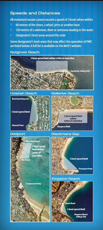
(b) Bellerive Beach: an area within 200 metres of the waterline extending eastward from the western end of the beach with the eastern extremity delineated by a sign on the beach;
(c) Blackmans Bay: all waters within an imaginary line drawn in a north-westerly direction from Flowerpot Point to the storm water outlet on Blackmans Bay Beach;
(d) Howrah Beach: all waters within an imaginary line drawn from Howrah Point to the boat launching area;
(e) Kingston Beach: waters within an imaginary line drawn from the Kingston Beach Sailing Club to a point on the beach at the end of Beach Road;
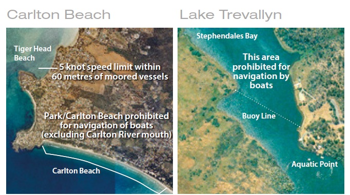
(f) Nutgrove Beach: an area within 200 metres of the waterline extending eastward from the western end of the beach to the Sandy Bay Sailing Club. - Waters of Tiger Head inside of an imaginary line drawn between the base of the boat launching ramp and the point in Dark Corner.
- Waters of the Carlton River upstream of an imaginary line drawn between beacons situated 400 metres from the mouth of the river.
- South Esk River-
(a) waters bounded in the south by the weir situated on the northern side of the Perth Bridge and in the north by the Perth Water Supply Pumping Station;
(b) waters bounded in the south by the convergence of the South Esk and Macquarie Rivers and in the north by the Mill Dam. - Waters of Lake Barrington within 60 metres of the launching ramps and pontoon structures at Kentish Park and Wilmot.
- Port area of Whitemark.
- Port area of Lady Barron. 12A. Brumbys Creek: all waters upstream of Brumbys Creek Weir 1.
- South Esk River west of Kings Park.
- Trevallyn Power Station Tailrace: to the west of an imaginary line drawn north-west from No. 3 light.
- West Arm: between one imaginary line, drawn northwards from the Riviera Hotel, through West Arm beacon, to the southernmost part of Anchor Point, and another imaginary line drawn from the shore south of Stingray Bay, via the northeastern and southwestern buoys southwards to the shore.
- Lagoon Bay: the marked ski access lane is for landing or picking up skiers only.
- Pipers Head: in the mouth of the Pipers River between the entrance and an imaginary line drawn eastward from Weymouth Boat Ramp.
- Bridport-
(a) Great Forester River: in the mouth of the Great Forester River from the northern end of the breakwater to the green and yellow pile with blue notice off Main Beach;
(b) Croquet Lawn Bay;
(c) all waters in Anderson Bay to 200 metres seaward of the shore bounded by an imaginary line drawn perpendicular to the shore at the northern end of Mermaids Beach and another such imaginary line drawn perpendicular to the shore at Pier Point. - The area within 200 metres of the waterline at the following:
(a) Mersey Bluff Beach;
(b) Coles Beach;
(c) East Devonport Beach (east and west side of breakwater);
(d) all Hawley and Port Sorell beaches;
(e) Squeaking Point;
(f) Panatana Rivulet;
(g) Forth River;
(h) Turners Beach;
(i) Ulverstone Sea Beaches. - The area on the Mersey River north of the Bass Highway bridge and south of an imaginary line drawn due east from the Victoria Parade boat ramp.
- Four Springs Lake.
- Arthurs Lake: waters of Cowpaddock Bay north of the transmission lines.
- Penstock Lagoon.
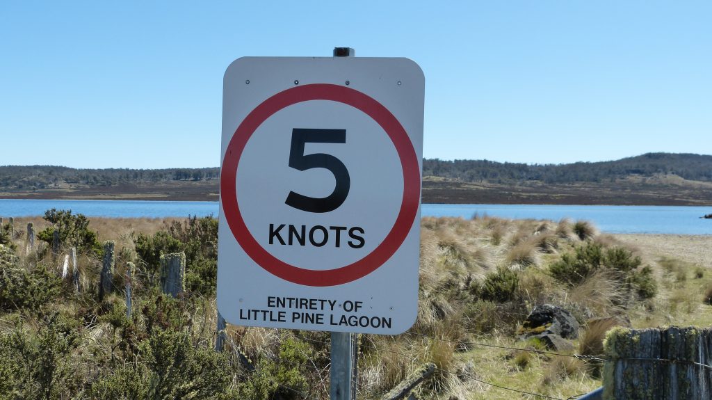
- Little Pine Lagoon.
- Bradys Lake/Lake Binney: waters of Bradys/Binney Canal.
- Lake Binney/Tungatinah Lagoon: waters of the Binney/Tungatinah Canal.
- Waters of Mossy Marsh.
- Waters of Pump Pond.
- Waters of Shannon Lagoon.
- Waters of Huntsman Lake.
- All waters of Prince of Wales Bay from Dowsings Point south-east at 140 degrees True to the opposite shoreline.
- Waters of Lake Paloona that are not prohibited for navigation in Schedule 2.
Motor boats, including PWC, are not permitted to operate in a “freestyle” manner when within 200 metres of a swimmer, or 200 metres of the shore if a dwelling is within 100 metres of that shoreline.
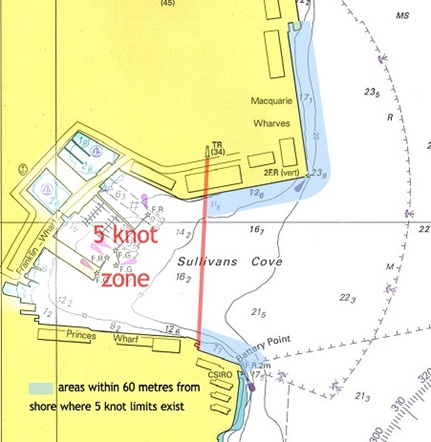
5 knot zones – Sullivans Cove
In accordance with Regulation 66 of the Marine and Safety (Pilotage and Navigation) Regulations 2017, Marine and Safety Tasmania (MAST) determines that a 5 knot zone exists within Sullivans Cove. This area shall be defined by a line drawn from the Port Control Tower to the eastern end of Princes Wharf Number 3, and includes all waters to the west of that line.
Mariners are reminded this 5 knot zone is in place to ensure that all users of the Sullivans Cove area undertake their operations within safe limits. The 5 knot zone does not alter the responsibility of mariners to ensure that vessels operate at 5 knots or less when within 60 metres of another vessel, structure or the shore. This is especially pertinent when entering or leaving the Sullivans Cove area.
The following chart identifies the defined 5 knot zone. It also indicates areas outside the zone that are within 60 metres of the shore.
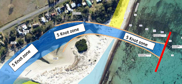
5 Knot Zone Prosser River
There is a designated 5 knot speed limit in all “waters of the Prosser river that are to seaward of the bridge on the Tasman Highway (and commonly known as the Prosser River Bridge or the Orford Bridge)”. This area extends to the River’s mouth which is the seaward end of the geotextile training walls.
Popular swimming areas where 5-knot zones exist